Why Choose Niche?
THE EXPERIENCED EYE OF THE PILOT
Along with drone and flying expertise, the professionals at Niche Aerial Services have an extensive background & in depth knowledge of the construction and engineering industries. This unique combination is paramount for delivering accurate inspection results. Here’s what some of our clients are saying about us…
Building Facade and Structural Inspections
“City Engineering and Design has retained Niche Aerial Services for many of our forensic building evaluations. As a forensic engineer, Niche aerial drone photography and infrared scans provided useful and critical documentation for my structural building assessments. Niche’s attention to detail, flight safety protocols and reports are comprehensive and well-organized. CITY strongly recommends using Niche Aerial Services!”
Orlando E. Ballate, Professional Engineer
Orlando E. Ballate, Professional Engineer
President of City Engineering and Design, PA
Infrared Thermography
“We utilize Niche Aerial Services for infrared roof scans to identify deficiencies in commercial roof surfaces/materials. This information is critical for our analysis and recommendations to our clients. Niche Aerial Services expertise and drones equipped with infrared technology offer a significant time and cost savings while delivering accurate results.”
Jeff VanNest
Jeff VanNest
Nu-tek Roofing
WHY FLY DRONES?
EFFICIENCY & ACCURACY OF THE INSPECTION PROCESS
- Time, labor and cost savings
- Insurance considerations
- Non-destructive methodology
- Accurate information & results
- Access to difficult locations
- Proactive/preventative
- Environmental considerations
- Vast, limitless applications
- Gathering valuable information in real-time
- Safety, safety, SAFETY
Wide variety of services
SPECIALIZED AERIAL INSPECTIONS
Our Services Include:
- Certified Infrared Thermography
- Commercial Roof Inspections
- Building Facade/Structural Imaging
- Insurance Investigations
- Property Mapping & Imaging
- Construction Progress Imaging
- Solar Field Inspections
- Infrastructure Inspections
completely accurate
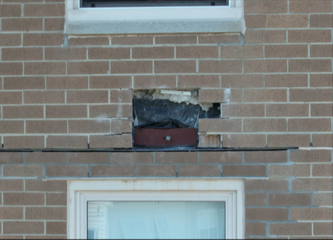
Building Facade Inspections
Structural/facade inspections have traditionally utilized unsafe scaffolding or lift equipment and numerous workers. Often these inspections have taken several weeks, if not months to complete, offering mediocre imaging and assessment at best.
Drone technology allows us to safely conduct accurate and thorough inspections. Utilizing high-resolution imaging yields inspection results in a fraction of the time, at a fraction of the cost. In addition, technology advances capture vital data that is otherwise unseen by traditional photography or the naked eye.
Drone technology allows us to safely conduct accurate and thorough inspections. Utilizing high-resolution imaging yields inspection results in a fraction of the time, at a fraction of the cost. In addition, technology advances capture vital data that is otherwise unseen by traditional photography or the naked eye.
capture critical info
Infrared Thermography
Infrared imaging utillizes the science of thermal dynamics to capture critical information for conditions “beneath the surface”, such as moisture penetration and insulation deficiencies.
Drone technology enables our FAA certified commercial UAS pilots to provide accurate inspection details while maintaining a safe environment, without the use of invasive/destructive procedures such as the traditional cutting/removal of materials known as core sampling.
Identify problems early
Property Surveys & Infrastructure
Drone technologies enable property mapping of large areas utilizing GPS positioning.
Infrastructure imaging and assessment of roadways, bridges, and tunnels via high-resolution cameras and infrared sensors can identify deficiencies and areas requiring repairs to prevent often catastrophic events.
Infrastructure imaging and assessment of roadways, bridges, and tunnels via high-resolution cameras and infrared sensors can identify deficiencies and areas requiring repairs to prevent often catastrophic events.
Inspections you can trust
gallery
Previous
Next


